Performing spatiotemporal analysis with Big Data involves analyzing data that is not only spatially distributed but also varies over time. Big Data technologies provide the necessary infrastructure and tools to effectively handle the large and complex datasets involved in spatiotemporal analysis. By leveraging Big Data platforms, analysts can gain valuable insights into trends, patterns, and correlations that may exist within geospatial and temporal dimensions. This article will explore the key considerations and techniques for conducting spatiotemporal analysis using Big Data, highlighting the importance of scalability, data integration, and advanced analytics in unlocking the full potential of spatial and temporal data resources.
Understanding Spatiotemporal Analysis
Spatiotemporal analysis refers to the study of phenomena that vary across both space and time. It combines geographical data and temporal data, allowing analysts to understand patterns and trends that emerge in datasets over time. In the realm of Big Data, this type of analysis becomes increasingly sophisticated due to the sheer volume, velocity, and variety of incoming data. Thus, organizations can derive valuable insights into behaviors, trends, and dynamics affecting various sectors.
The Importance of Spatiotemporal Analysis in Big Data
With the rapid proliferation of data generated from mobile devices, sensors, and social media, spatiotemporal analysis helps organizations gain a competitive edge. Here are a few key benefits:
- Enhanced Decision-Making: Integrating spatial and temporal data helps organizations make informed decisions based on real-time insights.
- Resource Optimization: Businesses can allocate resources more efficiently by understanding usage patterns over time.
- Predictive Analytics: Spatiotemporal analysis enables the prediction of future trends based on historical data.
Data Sources for Spatiotemporal Analysis
To perform effective spatiotemporal analysis, it’s essential to leverage the right data sources. Some common data sources include:
- Geospatial Datasets: Geographic Information Systems (GIS), satellite imagery, and demographic data.
- Sensor Data: IoT devices can provide real-time data on atmospheric conditions, traffic patterns, and more.
- Social Media: Platforms like Twitter and Instagram can offer insights into public sentiment and real-world activity over time.
- Mobile Data: Location data from mobile applications can track user behaviors geographically and temporally.
Tools for Spatiotemporal Analysis
Various tools and technologies are available to facilitate spatiotemporal analysis in Big Data. Here are some of the most popular options:
1. Geographic Information Systems (GIS)
GIS software is crucial for visualizing and analyzing spatial data. Prominent tools include:
- ArcGIS: A comprehensive GIS platform used for mapping, spatial analysis, and data visualization.
- QGIS: An open-source alternative that provides tools for data editing, analysis, and visualization.
2. Data Processing Frameworks
Big Data processing frameworks enable handling massive datasets efficiently. Popular frameworks include:
- Apache Spark: Offers in-built support for complex data processing and can handle spatiotemporal data via its GraphX and MLlib libraries.
- Apache Flink: A framework designed for real-time data processing that can analyze continuously updated datasets.
3. Statistical Software
Statistical software packages can conduct in-depth analysis on spatiotemporal data:
- R: With packages like sp and spacetime, R is highly effective for statistical modeling of spatiotemporal data.
- Python: Libraries like Pandas and GeoPandas facilitate analysis and manipulation of time series and geospatial data.
Steps to Conduct Spatiotemporal Analysis with Big Data
Performing spatiotemporal analysis involves several key steps:
Step 1: Data Collection
Collect data from various sources, ensuring the datasets include both spatial (location) and temporal (time) attributes. Make sure to include adequate metadata for clarity.
Step 2: Data Cleaning and Preprocessing
Clean the datasets to remove any inconsistencies, duplicates, or errors. Preprocessing may include:
- Normalizing data: Ensuring uniform formats for geographic coordinates and time stamps.
- Handling missing values: Implementing strategies to address gaps in data, such as interpolation or removal.
Step 3: Data Integration
Merge different datasets to create a comprehensive view, aligning time zones and projections to ensure accuracy.
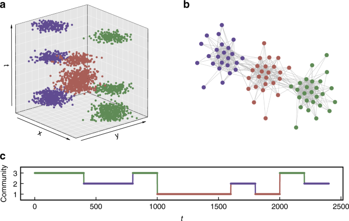
Step 4: Exploratory Data Analysis (EDA)
Conduct exploratory analysis to visualize spatial and temporal patterns. Use graphical representations such as:
- Heatmaps: To visualize concentrations of activity across spatial dimensions.
- Time Series Plots: To observe trends or anomalies over time.
Step 5: Model Development
Develop predictive models using statistical or machine learning approaches. Select algorithms suitable for time series forecasting, such as:
- ARIMA (Autoregressive Integrated Moving Average): Effective for temporal data with trends.
- Random Forest: Can capture complex relationships in both spatial and temporal features.
Step 6: Validation and Testing
Evaluate model performance using metrics like Mean Absolute Error (MAE) or Root Mean Squared Error (RMSE). Splitting the data into training and testing sets is fundamental for accurate validation.
Step 7: Visualization and Interpretation
Utilize visualization tools to present findings. Effective communication of spatiotemporal insights enhances understanding and decision-making. Consider using:
- Dashboards: To provide real-time monitoring of spatiotemporal trends.
- 3D Visualization: To present geographical data in a more intuitive way.
Common Challenges in Spatiotemporal Analysis
While performing spatiotemporal analysis can yield profound insights, several challenges must be addressed:
- Data Volume: The large amounts of data can hinder real-time processing and analysis.
- Data Quality: Inconsistencies and inaccuracies in data can lead to flawed insights.
- Complex Models: Spatiotemporal datasets often lead to complex relationships, making model selection and interpretation challenging.
Future Trends in Spatiotemporal Analysis
As technology advances, the field of spatiotemporal analysis continues to evolve. Consider the following trends:
- Machine Learning Integration: Increasing adoption of machine learning algorithms enhances predictive capabilities in spatiotemporal data analysis.
- Real-time Data Processing: The need for real-time insights is driving the use of advanced processing frameworks like Apache Kafka.
- Cloud Computing: Utilizing cloud-based solutions allows for scalable storage and processing of large spatiotemporal datasets.
By understanding and implementing the techniques and tools outlined above, organizations can leverage spatiotemporal analysis to unlock valuable insights from their Big Data efforts, leading to improved operational efficiency and strategic decision-making.
Leveraging Big Data for spatiotemporal analysis offers immense opportunities to extract valuable insights from vast amounts of data spanning both space and time. By applying advanced analytics techniques and utilizing powerful computing technologies, organizations can uncover patterns, trends, and correlations that drive informed decision-making and innovation. Embracing this approach unlocks the potential to enhance various fields, from urban planning and environmental monitoring to transportation optimization and beyond, ultimately shaping a more data-driven and efficient future.
Related posts:
 What is Big Data? A Beginner’s Guide
 The Five Vs of Big Data: Volume, Velocity, Variety, Veracity, and Value
 Structured vs. Unstructured Data: Key Differences and Examples
 What is a Data Lake? Definition, Uses, and Benefits
 Introduction to Distributed Computing in Big Data
 Understanding Data Pipelines in Big Data
 Data Ingestion Techniques for Big Data Processing
 What is Apache Hadoop? A Complete Guide
 Understanding Apache Spark: Features and Use Cases
 What is Kafka? How it Powers Real-Time Big Data Applications
 Apache Flink vs. Apache Spark: Which One is Better?
 Introduction to NoSQL Databases for Big Data
 The Role of MongoDB in Big Data Analytics
 Understanding HBase: How it Works in the Hadoop Ecosystem